
- Home

- Watersheds - Illinois Basin (entire)
- Search Results
Search Results
Search Results For:
Watershed > Illinois Basin (entire)
65 links were found.
Jump to: Data Online Maps/GIS Models Publications Research and Programs Agencies/Organizations Visualizations/Video
Displaying Page 1 (of 4)
Page: 1 | 2 | 3 | 4 | [Next >>]
Data Online- 1 7-Day 10-Year Low Flow Maps
- These maps provide information on low flow conditions that might be expected to occur only during droughts (once in 10 years), and associated effluent discharges, water withdrawals, and flow regulations for most Illinois rivers and streams.
- 2 Flood Discharge Database
- FEMA-published and selected other statistical flood discharge values, searchable by watershed or county.
- 3 Hydrologic Units of Illinois
- This map provides the USGS level 8 Hydrologic Unit Codes (HUC 8s) for Illinois watersheds.
- 4 Illinois Water Quality
- EPA maintained website with links to all Illinois watershed water quality summary reports dating back to 1996.
- 5 National Weather Service
- Provides weather, water, and climate data, forecasts and warnings.
- 6 National Weather Service: River Watch, Mississippi River Basin
- Illinois River 5-day stage forecasts for three main river segments: Morris to LaSalle, Henry to Beardstown, and New LaGrange to Hardin. Includes links to Upper Mississippi Basin stage forecasts.
- 7 NAWQA Data Warehouse
- Searchable database of National Water Quality Assessment data.
- 8 Rivergages.com: Water Levels of Rivers and Lakes
- US Army Corps of Engineers maintained interface to easily access water level data for all Illinois Waterway measurement stations in tabular, graphical, or downloadable form. Divided by watershed.
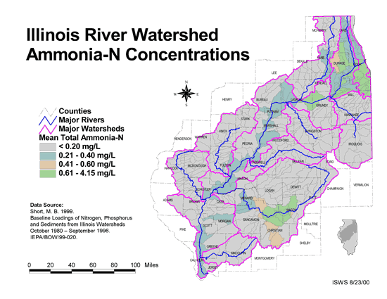
- 9 Ammonia-N Concentrations in the Illinois River Watershed
- Thematic map showing the mean total Ammonia-N for each of the major sub-watersheds.
- Download Options: LoRes preview | HiRes (624 K) | Metadata
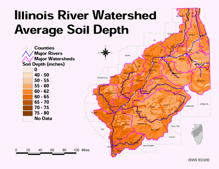
- 10 Average soil depth in the Illinois River Watershed
- Thematic map showing the average soil depth (inches) across the basin.
- Download Options: LoRes preview | HiRes (3.36 MB) | Metadata
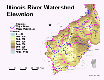
- 11 Elevation in the Illinois River Watershed
- Thematic map showing elevation changes in the basin.
- Download Options: LoRes preview | HiRes (1.76 MB) | Metadata
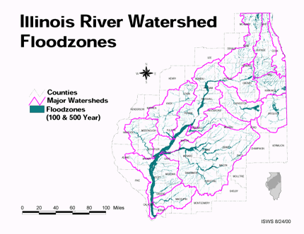
- 12 Floodzones in the Illinois River Watershed
- Thematic map showing the 100 and 500 year floodzones across the basin as of 1986.
- Download Options: LoRes preview | HiRes (3.77 MB) | Metadata
- 13 Illinois Floodplain Maps
- ISWS resource providing preliminary and final maps of Illinois floodplains.
- 14 Illinois River Basin GIS Data Viewer
- Interactive map provided by the ISWS. Viewable layers include watersheds, rivers, water quality, geology, and groundwater.
- 15 Illinois River Basin Weather Stations
- The weather stations in this data set were gathered from the WDM database within the Basins watershed modeling program. Coordinates for the stations were exported from Basins, then formatted and imported into ArcGIS. This data set was created to support research at the Illinois State Water Survey. (shapefile, .zip archive)

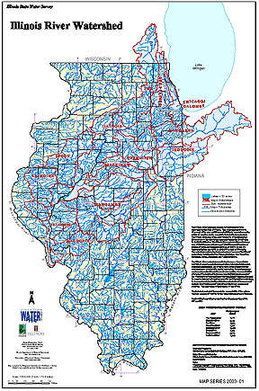
- 16 Illinois River Watershed - Poster
- Poster-sized (26x38) map of the entire Illinois River Watershed. Part of the Illinois State Water Survey published Map Series (2003-1)
- Download Options: LoRes preview | HiRes (3.5 MB) | Metadata
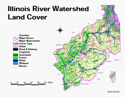
- 17 Land cover in the Illinois River Watershed
- Thematic map showing land cover from raster imagery.
- Download Options: LoRes preview | HiRes (2.68 MB) | Metadata
- 18 Major Watersheds of Illinois
- Poster-sized (26x38) map of the major watersheds in Illinois. Part of the Illinois State Water Survey published Map Series (2000-01)
- Download Options: LoRes preview | HiRes (730 K) | Metadata
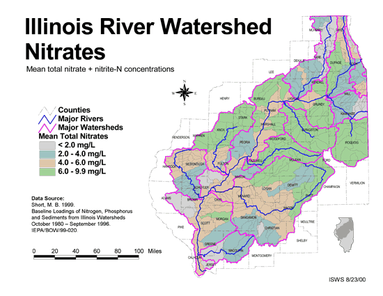
- 19 Nitrates in the Illinois River Watershed (mean total nitrate + nitrite-N concentrations)
- Thematic map showing the mean total nitrate + nitrite-N concentrations for each of the major sub-watersheds.
- Download Options: LoRes preview | HiRes (624 K) | Metadata
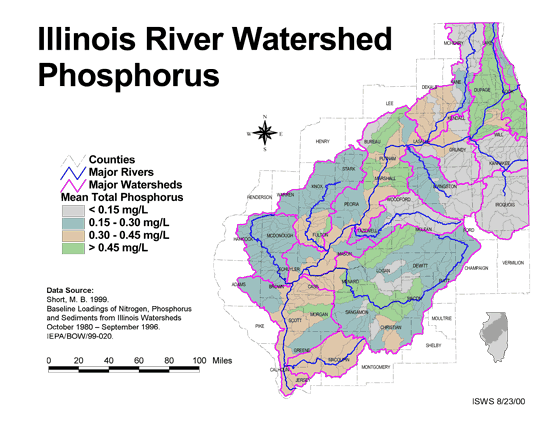
- 20 Phosphorus in the Illinois River Watershed
- Thematic map showing the mean total phosphorus concentrations for each of the major sub-watersheds.
- Download Options: LoRes preview | HiRes (624 K) | Metadata
- Home
- | Data
- | Maps/GIS
- | Models
- | Publications
- | Research
- | Agencies
- | Visualizations
All files and information © 2018 Illinois State Water Survey. Disclaimer.
Email the Web Administrator with questions or comments.