
Search Results
Search Results For:
All Maps/GIS
286 links were found.
Displaying Page 10 (of 15)
Page: [<< Prev] 1 | 2 | 3 | 4 | 5 | 6 | 7 | 8 | 9 | 10 | 11 | 12 | 13 | 14 | 15 | [Next >>]
Maps/GIS- 181 Mercer County Orthophotography Data 1998-1999
- Illinois National Aerial Photography Program Digital Orthophotography quarter Quadrangle data for Mercer County in the Universal Transverse Mercator (UTM) coordinate system with a NAD83 datum.

- 182 Monroe County Coal Maps
- ISGS Coal Map Series. Includes mines, resources, and logs.
- 183 Monroe County Orthophotography Data 1998-1999
- Illinois National Aerial Photography Program Digital Orthophotography quarter Quadrangle data for Monroe County in the Universal Transverse Mercator (UTM) coordinate system with a NAD83 datum.
- 184 Montgomery County Coal Maps
- ISGS Coal Map Series. Includes mines, resources, and logs.
- 185 Montgomery County Orthophotography Data 1998-1999
- Illinois National Aerial Photography Program Digital Orthophotography quarter Quadrangle data for Montgomery County in the Universal Transverse Mercator (UTM) coordinate system with a NAD83 datum.
- 186 Moraines (End Moraines) of the Wisconsin Episode
- Named Woodfordian moraines, or Wisconsinan End Moraines, of Illinois. GIS data (shapefile)
- 187 Morgan County Coal Maps
- ISGS Coal Map Series. Includes mines, resources, and logs.
- 188 Morgan County Orthophotography Data 1998-1999
- Illinois National Aerial Photography Program Digital Orthophotography quarter Quadrangle data for Morgan County in the Universal Transverse Mercator (UTM) coordinate system with a NAD83 datum.
- 189 Moultrie County Coal Maps
- ISGS Coal Map Series. Includes mines, resources, and logs.
- 190 Moultrie County Orthophotography Data 1998-1999
- Illinois National Aerial Photography Program Digital Orthophotography quarter Quadrangle data for Moultrie County in the Universal Transverse Mercator (UTM) coordinate system with a NAD83 datum.
- 191 Municipal Boundaries: Incorporated Places 2000
- Municipalities in Illinois with more than 250 people. Incorporated areas for all of Illinois. GIS data (shapefile)
- 192 National Flood Hazard Layer Web Map Service (WMS)
- This web site provides zipped Keyhole Markup Language (.kmz) files through which users can view map overlays created from FEMA's National Flood Hazard Layer on Google Earth images.
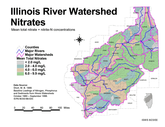
- 193 Nitrates in the Illinois River Watershed (mean total nitrate + nitrite-N concentrations)
- Thematic map showing the mean total nitrate + nitrite-N concentrations for each of the major sub-watersheds.
- Download Options: LoRes preview | HiRes (624 K) | Metadata
- 194 Ogle County Orthophotography Data 1998-1999
- Illinois National Aerial Photography Program Digital Orthophotography quarter Quadrangle data for Ogle County in the Universal Transverse Mercator (UTM) coordinate system with a NAD83 datum.
- 195 Peoria County Coal Maps
- ISGS Coal Map Series. Includes mines, resources, and logs.
- 196 Peoria County Orthophotography Data 1998-1999
- Illinois National Aerial Photography Program Digital Orthophotography quarter Quadrangle data for Peoria County in the Universal Transverse Mercator (UTM) coordinate system with a NAD83 datum.
- 197 Perry County Coal Maps
- ISGS Coal Map Series. Includes mines, resources, and logs.
- 198 Perry County Orthophotography Data 1998-1999
- Illinois National Aerial Photography Program Digital Orthophotography quarter Quadrangle data for Perry County in the Universal Transverse Mercator (UTM) coordinate system with a NAD83 datum.
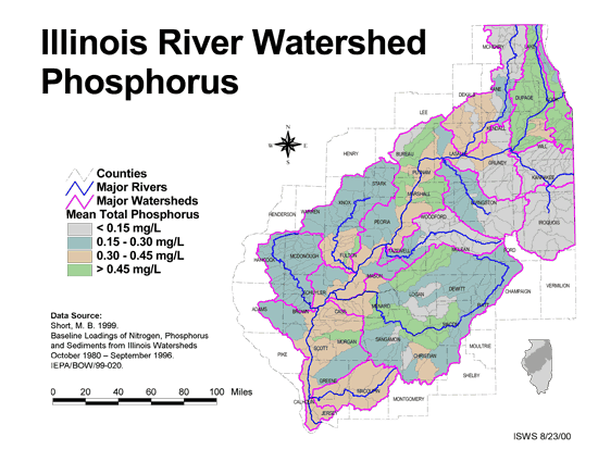
- 199 Phosphorus in the Illinois River Watershed
- Thematic map showing the mean total phosphorus concentrations for each of the major sub-watersheds.
- Download Options: LoRes preview | HiRes (624 K) | Metadata
- 200 Physiographic Divisions
- The Physiographic divisions of Illinois, including Provinces, Sections, and Divisions. GIS data (shapefile)
Page: [<< Prev] 1 | 2 | 3 | 4 | 5 | 6 | 7 | 8 | 9 | 10 | 11 | 12 | 13 | 14 | 15 | [Next >>]
- Home
- | Data
- | Maps/GIS
- | Models
- | Publications
- | Research
- | Agencies
- | Visualizations
All files and information © 2018 Illinois State Water Survey. Disclaimer.
Email the Web Administrator with questions or comments.