
Search Results
Search Results For:
All Maps/GIS
286 links were found.
Displaying Page 3 (of 15)
Page: [<< Prev] 1 | 2 | 3 | 4 | 5 | 6 | 7 | 8 | 9 | 10 | 11 | 12 | 13 | 14 | 15 | [Next >>]
Maps/GIS- 41 Cumberland County Coal Maps
- ISGS Coal Map Series. Includes mines, resources, and logs.
- 42 Cumberland County Orthophotography Data 1998-1999
- Illinois National Aerial Photography Program Digital Orthophotography quarter Quadrangle data for Cumberland County in the Universal Transverse Mercator (UTM) coordinate system with a NAD83 datum.

- 43 De Kalb County Orthophotography Data 1998-1999
- Illinois National Aerial Photography Program Digital Orthophotography quarter Quadrangle data for De Kalb County in the Universal Transverse Mercator (UTM) coordinate system with a NAD83 datum.
- 44 Des Plaines River Watershed Orthophotography 2000
- Orthoimagery for the Des Plaines River Watershed from Year 2000 black-and-white aerial photography in the Illinois State Plane, East Zone with a NAD83 datum.
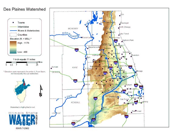
- 45 Des Plaines Watershed
- Thematic map of the Des Plaines watershed showing roads, county boundaries, and elevation changes.
- Download Options: LoRes preview | HiRes (1.71 MB) | Metadata
- 46 Dewitt County Coal Maps
- ISGS Coal Map Series. Includes mines, resources, and logs.
- 47 Dewitt County Orthophotography Data 1998-1999
- Illinois National Aerial Photography Program Digital Orthophotography quarter Quadrangle data for Dewitt County in the Universal Transverse Mercator (UTM) coordinate system with a NAD83 datum.
- 48 DOA Illinois Land Cover 1999-2000
- Land cover data for the state of Illinois provided by the Department of Agriculture.
- 49 Douglas County Coal Maps
- ISGS Coal Map Series. Includes mines, resources, and logs.
- 50 Douglas County Orthophotography Data 1998-1999
- Illinois National Aerial Photography Program Digital Orthophotography quarter Quadrangle data for Douglas County in the Universal Transverse Mercator (UTM) coordinate system with a NAD83 datum.
- 51 Driftless Areas
- Driftless areas in Illinois. These areas are analogous to areas of the state where the bedrock surface is not buried by glacial drift. GIS data (shapefile)
- 52 Dupage County Orthophotography Data 1998-1999
- Illinois National Aerial Photography Program Digital Orthophotography quarter Quadrangle data for Dupage County in the Universal Transverse Mercator (UTM) coordinate system with a NAD83 datum.
- 53 Edgar County Coal Maps
- ISGS Coal Map Series. Includes mines, resources, and logs.
- 54 Edgar County Orthophotography Data 1998-1999
- Illinois National Aerial Photography Program Digital Orthophotography quarter Quadrangle data for Edgar County in the Universal Transverse Mercator (UTM) coordinate system with a NAD83 datum.
- 55 EDNA Derived Watersheds for Major Named Rivers
- USGS dataset for viewing watershed data in KML format. Usable with Google Earth.
- 56 Edwards County Coal Maps
- ISGS Coal Map Series. Includes mines, resources, and logs.
- 57 Edwards County Orthophotography Data 1998-1999
- Illinois National Aerial Photography Program Digital Orthophotography quarter Quadrangle data for Edwards County in the Universal Transverse Mercator (UTM) coordinate system with a NAD83 datum.
- 58 Effingham County Coal Maps
- ISGS Coal Map Series. Includes mines, resources, and logs.
- 59 Effingham County Orthophotography Data 1998-1999
- Illinois National Aerial Photography Program Digital Orthophotography quarter Quadrangle data for Effingham County in the Universal Transverse Mercator (UTM) coordinate system with a NAD83 datum.
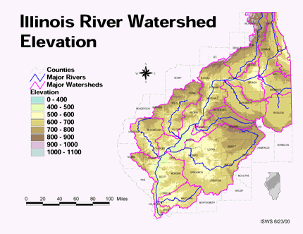
- 60 Elevation in the Illinois River Watershed
- Thematic map showing elevation changes in the basin.
- Download Options: LoRes preview | HiRes (1.76 MB) | Metadata
Page: [<< Prev] 1 | 2 | 3 | 4 | 5 | 6 | 7 | 8 | 9 | 10 | 11 | 12 | 13 | 14 | 15 | [Next >>]
- Home
- | Data
- | Maps/GIS
- | Models
- | Publications
- | Research
- | Agencies
- | Visualizations
All files and information © 2018 Illinois State Water Survey. Disclaimer.
Email the Web Administrator with questions or comments.