
Search Results
Search Results For:
All Maps/GIS
286 links were found.
Displaying Page 7 (of 15)
Page: [<< Prev] 1 | 2 | 3 | 4 | 5 | 6 | 7 | 8 | 9 | 10 | 11 | 12 | 13 | 14 | 15 | [Next >>]
Maps/GIS- 121 Indian Treaty Boundary Lines
- Indian Treaty boundary lines from the Illinois Public Land Survey System. ISGS, 1984 (revised 2003). GIS data (shapefile)

- 122 Iroquois County Coal Maps
- ISGS Coal Map Series. Includes mines, resources, and logs.
- 123 Iroquois County Orthophotography Data 1998-1999
- Illinois National Aerial Photography Program Digital Orthophotography quarter Quadrangle data for Iroquois County in the Universal Transverse Mercator (UTM) coordinate system with a NAD83 datum.
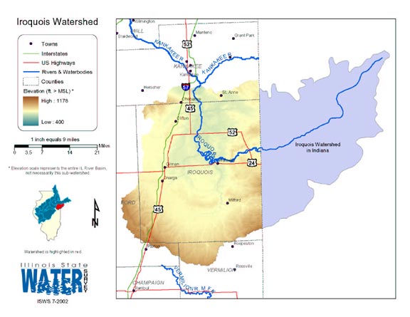
- 124 Iroquois Watershed
- Thematic map of the Iroquois watershed showing roads, county boundaries, and elevation changes.
- Download Options: LoRes preview | HiRes (1.03 MB) | Metadata
- 125 Jackson County Coal Maps
- ISGS Coal Map Series. Includes mines, resources, and logs.
- 126 Jackson County Orthophotography Data 1998-1999
- Illinois National Aerial Photography Program Digital Orthophotography quarter Quadrangle data for Jackson County in the Universal Transverse Mercator (UTM) coordinate system with a NAD83 datum.
- 127 Jasper County Coal Maps
- ISGS Coal Map Series. Includes mines, resources, and logs.
- 128 Jasper County Orthophotography Data 1998-1999
- Illinois National Aerial Photography Program Digital Orthophotography quarter Quadrangle data for Jasper County in the Universal Transverse Mercator (UTM) coordinate system with a NAD83 datum.
- 129 Jefferson County Coal Maps
- ISGS Coal Map Series. Includes mines, resources, and logs.
- 130 Jefferson County Orthophotography Data 1998-1999
- Illinois National Aerial Photography Program Digital Orthophotography quarter Quadrangle data for Jefferson County in the Universal Transverse Mercator (UTM) coordinate system with a NAD83 datum.
- 131 Jersey County Coal Maps
- ISGS Coal Map Series. Includes mines, resources, and logs.
- 132 Jersey County Orthophotography Data 1998-1999
- Illinois National Aerial Photography Program Digital Orthophotography quarter Quadrangle data for Jersey County in the Universal Transverse Mercator (UTM) coordinate system with a NAD83 datum.
- 133 Jo Daviess County Orthophotography Data 1998-1999
- Illinois National Aerial Photography Program Digital Orthophotography quarter Quadrangle data for Jo Daviess County in the Universal Transverse Mercator (UTM) coordinate system with a NAD83 datum.
- 134 Johnson County Coal Maps
- ISGS Coal Map Series. Includes mines, resources, and logs.
- 135 Johnson County Orthophotography Data 1998-1999
- Illinois National Aerial Photography Program Digital Orthophotography quarter Quadrangle data for Johnson County in the Universal Transverse Mercator (UTM) coordinate system with a NAD83 datum.
- 136 Kane County Orthophotography Data 1998-1999
- Illinois National Aerial Photography Program Digital Orthophotography quarter Quadrangle data for Kane County in the Universal Transverse Mercator (UTM) coordinate system with a NAD83 datum.
- 137 Kankakee County Coal Maps
- ISGS Coal Map Series. Includes mines, resources, and logs.
- 138 Kankakee County Orthophotography Data 1998-1999
- Illinois National Aerial Photography Program Digital Orthophotography quarter Quadrangle data for Kankakee County in the Universal Transverse Mercator (UTM) coordinate system with a NAD83 datum.
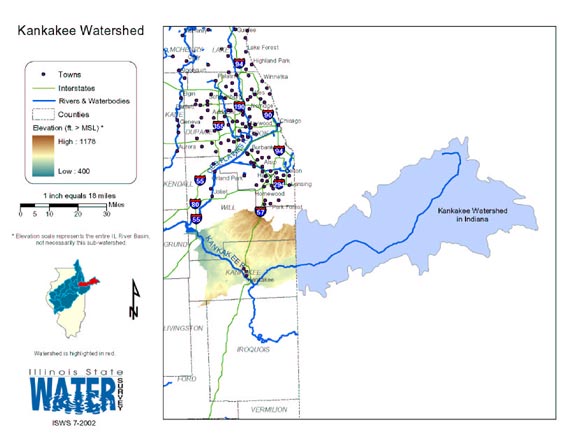
- 139 Kankakee Watershed Map
- Thematic map of the Kankakee watershed showing roads, county boundaries, and elevation changes.
- Download Options: LoRes preview | HiRes (1.05 MB) | Metadata
- 140 Kendall County Orthophotography Data 1998-1999
- Illinois National Aerial Photography Program Digital Orthophotography quarter Quadrangle data for Kendall County in the Universal Transverse Mercator (UTM) coordinate system with a NAD83 datum.
Page: [<< Prev] 1 | 2 | 3 | 4 | 5 | 6 | 7 | 8 | 9 | 10 | 11 | 12 | 13 | 14 | 15 | [Next >>]
- Home
- | Data
- | Maps/GIS
- | Models
- | Publications
- | Research
- | Agencies
- | Visualizations
All files and information © 2018 Illinois State Water Survey. Disclaimer.
Email the Web Administrator with questions or comments.