
- Home

- Watersheds - Illinois River Valley
- Search Results
Search Results
Search Results For:
Watershed > Illinois River Valley
443 links were found.
Jump to: Data Online Maps/GIS Models Publications Research and Programs Agencies/Organizations Visualizations/Video
Displaying Page 6 (of 23)
Page: [<< Prev] 1 | 2 | 3 | 4 | 5 | 6 | 7 | 8 | 9 | 10 | 11 | 12 | 13 | 14 | 15 | 16 | 17 | 18 | 19 | 20 | 21 | 22 | 23 | [Next >>]
Maps/GIS- 101 1993 Mississippi River Flood Hazard Mitigation Grant Program
- 1993 Mississippi River flood maps that show properties damaged in the event.
- 102 Adams County Coal Maps
- ISGS Coal Map Series. Includes mines, resources, and logs.
- 103 Adams County Orthophotography Data 1998-1999
- Illinois National Aerial Photography Program Digital Orthophotography quarter Quadrangle data for Adams County in the Universal Transverse Mercator (UTM) coordinate system with a NAD83 datum.

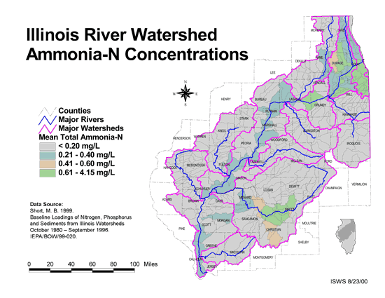
- 104 Ammonia-N Concentrations in the Illinois River Watershed
- Thematic map showing the mean total Ammonia-N for each of the major sub-watersheds.
- Download Options: LoRes preview | HiRes (624 K) | Metadata
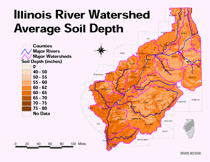
- 105 Average soil depth in the Illinois River Watershed
- Thematic map showing the average soil depth (inches) across the basin.
- Download Options: LoRes preview | HiRes (3.36 MB) | Metadata
- 106 Brown County Coal Maps
- ISGS Coal Map Series. Includes mines, resources, and logs.
- 107 Brown County Orthophotography Data 1998-1999
- Illinois National Aerial Photography Program Digital Orthophotography quarter Quadrangle data for Brown County in the Universal Transverse Mercator (UTM) coordinate system with a NAD83 datum.
- 108 Bureau County Coal Maps
- ISGS Coal Map Series. Includes mines, resources, and logs.
- 109 Bureau County Orthophotography Data 1998-1999
- Illinois National Aerial Photography Program Digital Orthophotography quarter Quadrangle data for Bureau County in the Universal Transverse Mercator (UTM) coordinate system with a NAD83 datum.
- 110 Calhoun County Coal Maps
- ISGS Coal Map Series. Includes mines, resources, and logs.
- 111 Calhoun County Orthophotography Data 1998-1999
- Illinois National Aerial Photography Program Digital Orthophotography quarter Quadrangle data for Calhoun County in the Universal Transverse Mercator (UTM) coordinate system with a NAD83 datum.
- 112 Cass County Orthophotography Data 1998-1999
- Illinois National Aerial Photography Program Digital Orthophotography quarter Quadrangle data for Cass County in the Universal Transverse Mercator (UTM) coordinate system with a NAD83 datum.
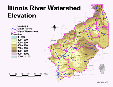
- 113 Elevation in the Illinois River Watershed
- Thematic map showing elevation changes in the basin.
- Download Options: LoRes preview | HiRes (1.76 MB) | Metadata
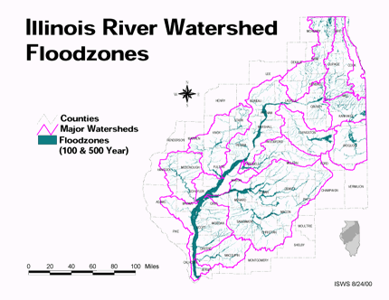
- 114 Floodzones in the Illinois River Watershed
- Thematic map showing the 100 and 500 year floodzones across the basin as of 1986.
- Download Options: LoRes preview | HiRes (3.77 MB) | Metadata
- 115 Ford County Coal Maps
- ISGS Coal Map Series. Includes mines, resources, and logs.
- 116 Ford County Orthophotography Data 1998-1999
- Illinois National Aerial Photography Program Digital Orthophotography quarter Quadrangle data for Ford County in the Universal Transverse Mercator (UTM) coordinate system with a NAD83 datum.
- 117 Fulton County Coal Maps
- ISGS Coal Map Series. Includes mines, resources, and logs.
- 118 Fulton County Orthophotography Data 1998-1999
- Illinois National Aerial Photography Program Digital Orthophotography quarter Quadrangle data for Fulton County in the Universal Transverse Mercator (UTM) coordinate system with a NAD83 datum.
- 119 Greene County Coal Maps
- ISGS Coal Map Series. Includes mines, resources, and logs.
- 120 Greene County Orthophotography Data 1998-1999
- Illinois National Aerial Photography Program Digital Orthophotography quarter Quadrangle data for Greene County in the Universal Transverse Mercator (UTM) coordinate system with a NAD83 datum.
Page: [<< Prev] 1 | 2 | 3 | 4 | 5 | 6 | 7 | 8 | 9 | 10 | 11 | 12 | 13 | 14 | 15 | 16 | 17 | 18 | 19 | 20 | 21 | 22 | 23 | [Next >>]
- Home
- | Data
- | Maps/GIS
- | Models
- | Publications
- | Research
- | Agencies
- | Visualizations
All files and information © 2018 Illinois State Water Survey. Disclaimer.
Email the Web Administrator with questions or comments.