
- Home

- Watersheds - Illinois River Valley
- Search Results
Search Results
Search Results For:
Watershed > Illinois River Valley
443 links were found.
Jump to: Data Online Maps/GIS Models Publications Research and Programs Agencies/Organizations Visualizations/Video
Displaying Page 8 (of 23)
Page: [<< Prev] 1 | 2 | 3 | 4 | 5 | 6 | 7 | 8 | 9 | 10 | 11 | 12 | 13 | 14 | 15 | 16 | 17 | 18 | 19 | 20 | 21 | 22 | 23 | [Next >>]
Maps/GIS- 141 Macoupin County Coal Maps
- ISGS Coal Map Series. Includes mines, resources, and logs.
- 142 Macoupin County Orthophotography Data 1998-1999
- Illinois National Aerial Photography Program Digital Orthophotography quarter Quadrangle data for Macoupin County in the Universal Transverse Mercator (UTM) coordinate system with a NAD83 datum.

- 143 Major Watersheds of Illinois
- Poster-sized (26x38) map of the major watersheds in Illinois. Part of the Illinois State Water Survey published Map Series (2000-01)
- Download Options: LoRes preview | HiRes (730 K) | Metadata
- 144 Marshall County Coal Maps
- ISGS Coal Map Series. Includes mines, resources, and logs.
- 145 Marshall County Orthophotography Data 1998-1999
- Illinois National Aerial Photography Program Digital Orthophotography quarter Quadrangle data for Marshall County in the Universal Transverse Mercator (UTM) coordinate system with a NAD83 datum.
- 146 Mason County Coal Maps
- ISGS Coal Map Series. Includes mines, resources, and logs.
- 147 Mason County Orthophotography Data 1998-1999
- Illinois National Aerial Photography Program Digital Orthophotography quarter Quadrangle data for Mason County in the Universal Transverse Mercator (UTM) coordinate system with a NAD83 datum.
- 148 McDonough County Coal Maps
- ISGS Coal Map Series. Includes mines, resources, and logs.
- 149 McDonough County Orthophotography Data 1998-1999
- Illinois National Aerial Photography Program Digital Orthophotography quarter Quadrangle data for McDonough County in the Universal Transverse Mercator (UTM) coordinate system with a NAD83 datum.
- 150 Morgan County Coal Maps
- ISGS Coal Map Series. Includes mines, resources, and logs.
- 151 Morgan County Orthophotography Data 1998-1999
- Illinois National Aerial Photography Program Digital Orthophotography quarter Quadrangle data for Morgan County in the Universal Transverse Mercator (UTM) coordinate system with a NAD83 datum.
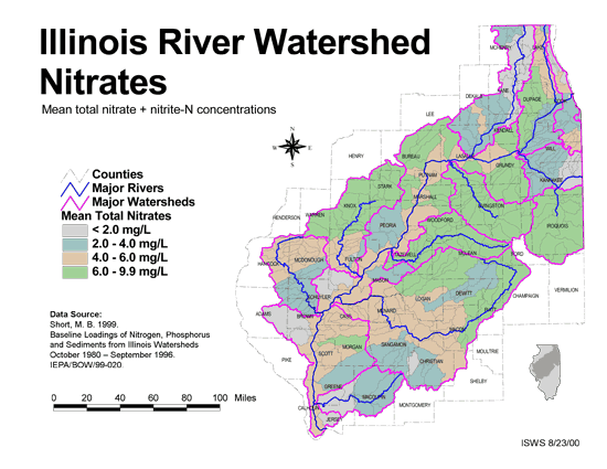
- 152 Nitrates in the Illinois River Watershed (mean total nitrate + nitrite-N concentrations)
- Thematic map showing the mean total nitrate + nitrite-N concentrations for each of the major sub-watersheds.
- Download Options: LoRes preview | HiRes (624 K) | Metadata
- 153 Peoria County Coal Maps
- ISGS Coal Map Series. Includes mines, resources, and logs.
- 154 Peoria County Orthophotography Data 1998-1999
- Illinois National Aerial Photography Program Digital Orthophotography quarter Quadrangle data for Peoria County in the Universal Transverse Mercator (UTM) coordinate system with a NAD83 datum.
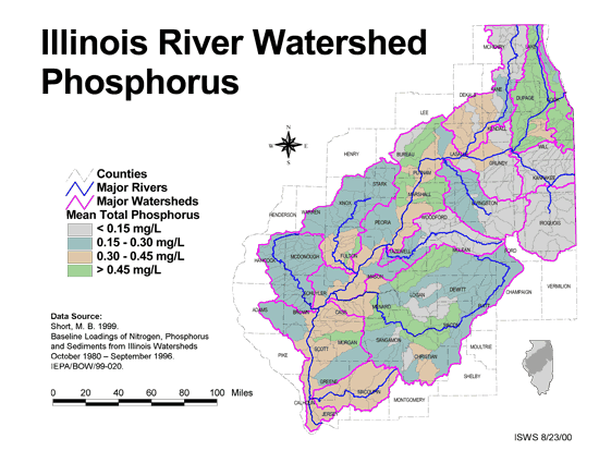
- 155 Phosphorus in the Illinois River Watershed
- Thematic map showing the mean total phosphorus concentrations for each of the major sub-watersheds.
- Download Options: LoRes preview | HiRes (624 K) | Metadata
- 156 Pike County Coal Maps
- ISGS Coal Map Series. Includes mines, resources, and logs.
- 157 Pike County Orthophotography Data 1998-1999
- Illinois National Aerial Photography Program Digital Orthophotography quarter Quadrangle data for Pike County in the Universal Transverse Mercator (UTM) coordinate system with a NAD83 datum.
- 158 Putnam County Coal Maps
- ISGS Coal Map Series. Includes mines, resources, and logs.
- 159 Putnam County Orthophotography Data 1998-1999
- Illinois National Aerial Photography Program Digital Orthophotography quarter Quadrangle data for Putnam County in the Universal Transverse Mercator (UTM) coordinate system with a NAD83 datum.
- 160 Resource Management Mapping Service
- Interactive map that allows users to locate, create, and print maps of large and small areas within Illinois. Natural resource, administrative, and economic layers available.
Page: [<< Prev] 1 | 2 | 3 | 4 | 5 | 6 | 7 | 8 | 9 | 10 | 11 | 12 | 13 | 14 | 15 | 16 | 17 | 18 | 19 | 20 | 21 | 22 | 23 | [Next >>]
- Home
- | Data
- | Maps/GIS
- | Models
- | Publications
- | Research
- | Agencies
- | Visualizations
All files and information © 2018 Illinois State Water Survey. Disclaimer.
Email the Web Administrator with questions or comments.