
- Home

- Watersheds - Mackinaw
- Search Results
Search Results
Search Results For:
Watershed > Mackinaw
150 links were found.
Jump to: Data Online Maps/GIS Models Publications Research and Programs Agencies/Organizations
Displaying Page 3 (of 8)
Page: [<< Prev] 1 | 2 | 3 | 4 | 5 | 6 | 7 | 8 | [Next >>]
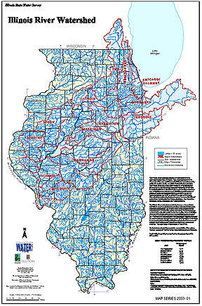
Maps/GIS- 41 Illinois River Watershed - Poster
- Poster-sized (26x38) map of the entire Illinois River Watershed. Part of the Illinois State Water Survey published Map Series (2003-1)
- Download Options: LoRes preview | HiRes (3.5 MB) | Metadata
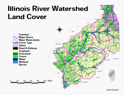
- 42 Land cover in the Illinois River Watershed
- Thematic map showing land cover from raster imagery.
- Download Options: LoRes preview | HiRes (2.68 MB) | Metadata
- 43 Livingston County Coal Maps
- ISGS Coal Map Series. Includes mines, resources, and logs.
- 44 Livingston County Orthophotography Data 1998-1999
- Illinois National Aerial Photography Program Digital Orthophotography quarter Quadrangle data for Livingston County in the Universal Transverse Mercator (UTM) coordinate system with a NAD83 datum.

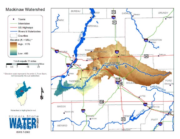
- 45 Mackinaw Watershed Map
- Thematic map of the Mackinaw watershed showing roads, county boundaries, and elevation changes.
- Download Options: LoRes preview | HiRes (2.61 MB) | Metadata
- 46 Major Watersheds of Illinois
- Poster-sized (26x38) map of the major watersheds in Illinois. Part of the Illinois State Water Survey published Map Series (2000-01)
- Download Options: LoRes preview | HiRes (730 K) | Metadata
- 47 Mason County Coal Maps
- ISGS Coal Map Series. Includes mines, resources, and logs.
- 48 Mason County Orthophotography Data 1998-1999
- Illinois National Aerial Photography Program Digital Orthophotography quarter Quadrangle data for Mason County in the Universal Transverse Mercator (UTM) coordinate system with a NAD83 datum.
- 49 McLean County Coal Maps
- ISGS Coal Map Series. Includes mines, resources, and logs.
- 50 McLean County Orthophotography Data 1998-1999
- Illinois National Aerial Photography Program Digital Orthophotography quarter Quadrangle data for McLean County in the Universal Transverse Mercator (UTM) coordinate system with a NAD83 datum.
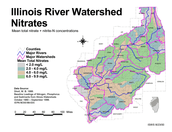
- 51 Nitrates in the Illinois River Watershed (mean total nitrate + nitrite-N concentrations)
- Thematic map showing the mean total nitrate + nitrite-N concentrations for each of the major sub-watersheds.
- Download Options: LoRes preview | HiRes (624 K) | Metadata
- 52 Phosphorus in the Illinois River Watershed
- Thematic map showing the mean total phosphorus concentrations for each of the major sub-watersheds.
- Download Options: LoRes preview | HiRes (624 K) | Metadata
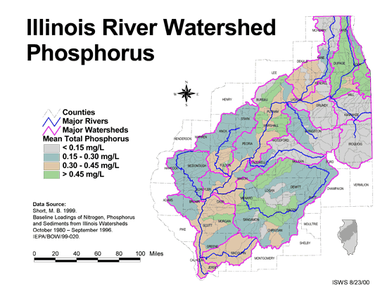
- 53 Resource Management Mapping Service
- Interactive map that allows users to locate, create, and print maps of large and small areas within Illinois. Natural resource, administrative, and economic layers available.
- 54 Sediment delivery to the main stem of the Illinois River
- Using sediment delivery classes, this map describes sediment delivery to the Illinois River from the major sub-watersheds.
- Download Options: LoRes preview | HiRes (630 K) | Metadata
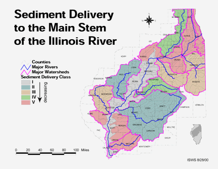
- 55 Soil organic matter in the Illinois River Watershed
- Thematic map showing the percent organic matter for each of the major sub-watersheds.
- Download Options: LoRes preview | HiRes (4.69 MB) | Metadata
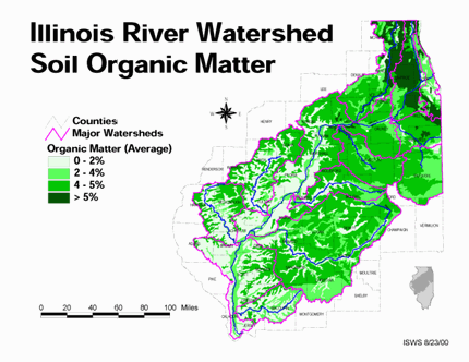
- 56 Tazewell County Coal Maps
- ISGS Coal Map Series. Includes mines, resources, and logs.
- 57 Tazewell County Orthophotography Data 1998-1999
- Illinois National Aerial Photography Program Digital Orthophotography quarter Quadrangle data for Tazewell County in the Universal Transverse Mercator (UTM) coordinate system with a NAD83 datum.
- 58 Total suspended solids in the Illinois River Watershed
- Thematic map showing the mean TSS concentrations for each of the major sub-watersheds.
- Download Options: LoRes preview | HiRes (626 K) | Metadata
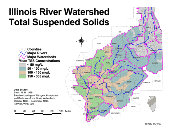
- 59 Woodford County Coal Maps
- ISGS Coal Map Series. Includes mines, resources, and logs.
- 60 Woodford County Orthophotography Data 1998-1999
- Illinois National Aerial Photography Program Digital Orthophotography quarter Quadrangle data for Woodford County in the Universal Transverse Mercator (UTM) coordinate system with a NAD83 datum.
- Home
- | Data
- | Maps/GIS
- | Models
- | Publications
- | Research
- | Agencies
- | Visualizations
All files and information © 2018 Illinois State Water Survey. Disclaimer.
Email the Web Administrator with questions or comments.