
- Home

- Counties - Dupage
- Search Results
Search Results
Search Results For:
County > Dupage
177 links were found.
Jump to: Data Online Maps/GIS Publications Research and Programs Agencies/Organizations
Displaying Page 1 (of 9)
Page: 1 | 2 | 3 | 4 | 5 | 6 | 7 | 8 | 9 | [Next >>]
Data Online- 1 7-Day 10-Year Low Flow Maps
- These maps provide information on low flow conditions that might be expected to occur only during droughts (once in 10 years), and associated effluent discharges, water withdrawals, and flow regulations for most Illinois rivers and streams.
- 2 Census 2010 Analysis for Northeastern Illinois
- Link to the Chicago Metropolitan Agency for Planning (CMAP) regional demographic analysis of Census 2010 results.
- 3 Des Plaines Watershed Profile
- Environmental Protection Agency website containing numerous links to environmental data about the Des Plaines watershed.
- 4 Des Plaines Watershed Resource Links
- USGS maintained site with links to data, projects, and publications on HUC watersheds
- 5 Des Plaines Watershed Water Data
- The USGS National Water Information System provides real-time and historical data on surface water flow, ground water levels, and water quality of streams in the US.
- 6 DuPage County Water Data
- The USGS National Water Information System provides real-time and historical data on surface water flow, ground water levels, and water quality of streams in the US.
- 7 Flood Discharge Database
- FEMA-published and selected other statistical flood discharge values, searchable by watershed or county.
- 8 Fox Watershed - Tributary Watersheds - GIS Page
- An ILRDSS webpage with links to 62 zipped shapefiles containing Fox River Tributary watersheds and subwatersheds data.
- 9 Illinois Water Quality
- EPA maintained website with links to all Illinois watershed water quality summary reports dating back to 1996.
- 10 Lower Fox Watershed Profile
- Environmental Protection Agency website containing numerous links to environmental data about the Lower Fox watershed.
- 11 Lower Fox Watershed Resource Links
- USGS maintained site with links to data, projects, and publications on HUC watersheds
- 12 Lower Fox Watershed Water Data
- The USGS National Water Information System provides real-time and historical data on surface water flow, ground water levels, and water quality of streams in the US.
- 13 Monthly Climate Data- Wheaton, IL
- Monthly precipitation and temperature data provided by the State Climatologist. Data available from 1901-present.
- 14 National Weather Service: River Watch, Mississippi River Basin
- Illinois River 5-day stage forecasts for three main river segments: Morris to LaSalle, Henry to Beardstown, and New LaGrange to Hardin. Includes links to Upper Mississippi Basin stage forecasts.
- 15 NAWQA Data Warehouse
- Searchable database of National Water Quality Assessment data.
- 16 NTN data: Argonne, DuPage County, IL
- This National Trends Network (NTN) monitoring location provides long-term precipitation data for Argonne in DuPage County, IL.
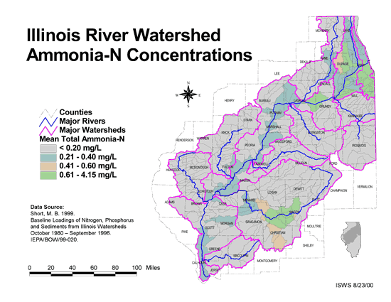
- 17 Ammonia-N Concentrations in the Illinois River Watershed
- Thematic map showing the mean total Ammonia-N for each of the major sub-watersheds.
- Download Options: LoRes preview | HiRes (624 K) | Metadata
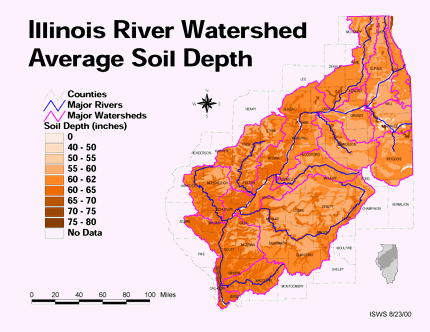
- 18 Average soil depth in the Illinois River Watershed
- Thematic map showing the average soil depth (inches) across the basin.
- Download Options: LoRes preview | HiRes (3.36 MB) | Metadata
- 19 Des Plaines River Watershed Orthophotography 2000
- Orthoimagery for the Des Plaines River Watershed from Year 2000 black-and-white aerial photography in the Illinois State Plane, East Zone with a NAD83 datum.

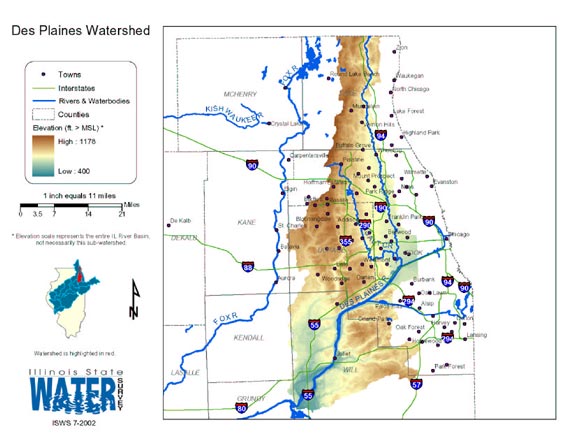
- 20 Des Plaines Watershed
- Thematic map of the Des Plaines watershed showing roads, county boundaries, and elevation changes.
- Download Options: LoRes preview | HiRes (1.71 MB) | Metadata
- Home
- | Data
- | Maps/GIS
- | Models
- | Publications
- | Research
- | Agencies
- | Visualizations
All files and information © 2018 Illinois State Water Survey. Disclaimer.
Email the Web Administrator with questions or comments.