
- Home

- Counties - Cook
- Search Results
Search Results
Search Results For:
County > Cook
267 links were found.
Jump to: Data Online Maps/GIS Publications Research and Programs Agencies/Organizations Visualizations/Video
Displaying Page 3 (of 14)
Page: [<< Prev] 1 | 2 | 3 | 4 | 5 | 6 | 7 | 8 | 9 | 10 | 11 | 12 | 13 | 14 | [Next >>]
Data Online- 41 National Weather Service: River Watch, Mississippi River Basin
- Illinois River 5-day stage forecasts for three main river segments: Morris to LaSalle, Henry to Beardstown, and New LaGrange to Hardin. Includes links to Upper Mississippi Basin stage forecasts.
- 42 NAWQA Data Warehouse
- Searchable database of National Water Quality Assessment data.
- 43 Pan Evaporation Across Illinois
- Pan evaporation measurements taken at 9 sites across Illinois.
- 44 Pike-Root Watershed Profile
- Environmental Protection Agency website containing numerous links to environmental data about the Pike-Root watershed.
- 45 Pike-Root Watershed Resource Links
- USGS maintained site with links to data, projects, and publications on HUC watersheds.
- 46 Pike-Root Watershed Water Data
- The USGS National Water Information System provides real-time and historical data on surface water flow, ground water levels, and water quality of streams in the US.
- 47 Upper Fox Watershed Profile
- Environmental Protection Agency website containing numerous links to environmental data about the Upper Fox watershed.
- 48 Upper Fox Watershed Resource Links
- USGS maintained site with links to data, projects, and publications on HUC watersheds
- 49 Upper Fox Watershed Water Data
- The USGS National Water Information System provides real-time and historical data on surface water flow, ground water levels, and water quality of streams in the US.
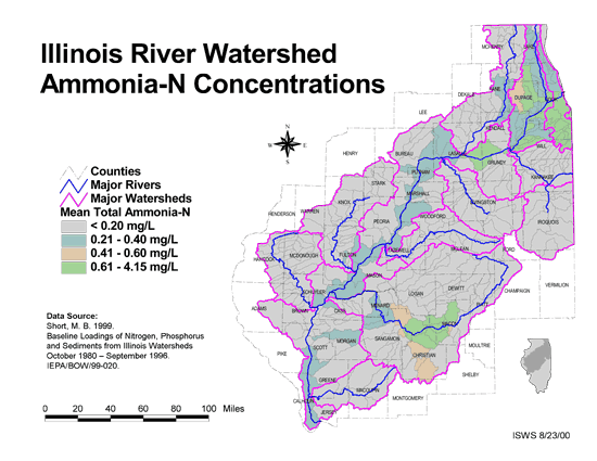
- 50 Ammonia-N Concentrations in the Illinois River Watershed
- Thematic map showing the mean total Ammonia-N for each of the major sub-watersheds.
- Download Options: LoRes preview | HiRes (624 K) | Metadata
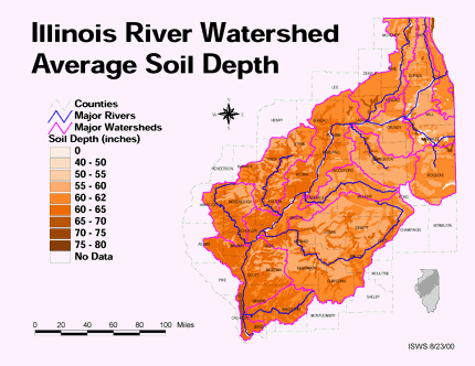
- 51 Average soil depth in the Illinois River Watershed
- Thematic map showing the average soil depth (inches) across the basin.
- Download Options: LoRes preview | HiRes (3.36 MB) | Metadata
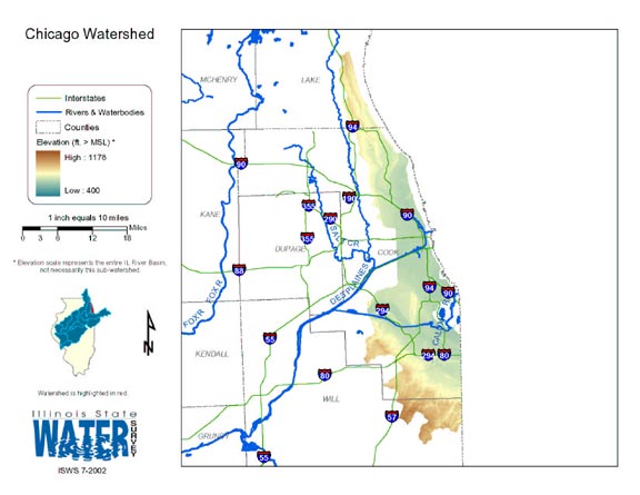
- 52 Chicago Watershed
- Thematic map of the Chicago watershed showing roads, county boundaries, and elevation changes.
- Download Options: LoRes preview | HiRes (1.57 MB) | Metadata
- 53 Cook County Orthophotography Data 1998-1999
- Illinois National Aerial Photography Program Digital Orthophotography quarter Quadrangle data for Cook County in the Universal Transverse Mercator (UTM) coordinate system with a NAD83 datum.

- 54 Des Plaines River Watershed Orthophotography 2000
- Orthoimagery for the Des Plaines River Watershed from Year 2000 black-and-white aerial photography in the Illinois State Plane, East Zone with a NAD83 datum.
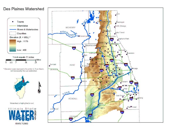
- 55 Des Plaines Watershed
- Thematic map of the Des Plaines watershed showing roads, county boundaries, and elevation changes.
- Download Options: LoRes preview | HiRes (1.71 MB) | Metadata
- 56 Elevation in the Illinois River Watershed
- Thematic map showing elevation changes in the basin.
- Download Options: LoRes preview | HiRes (1.76 MB) | Metadata
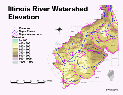
- 57 Floodzones in the Illinois River Watershed
- Thematic map showing the 100 and 500 year floodzones across the basin as of 1986.
- Download Options: LoRes preview | HiRes (3.77 MB) | Metadata
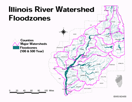
- 58 Fox River Tributary Watersheds and Subwatersheds
- Fox River Tributary watersheds and subwatersheds (62 individual shapefiles) created through BASINS automatic delineation, as part of the Fox River Watershed Investigation (shapefile, .zip archive). Note - To download individual shapefiles, visit the Fox River Tributary Watershed GIS Page: http://ilrdss.sws.uiuc.edu/fox/tributaries_gis.aspx
- 59 Fox Watershed - Ambient Water Quality Monitoring Network (AWQMN)
- The Ambient Water Quality Monitoring Network is managed by the Illinois Environmental Protection Agency. This data set shows locations of all fixed monitoring sites in the Fox Watershed. This data is a sub-set of a state-wide data set. Data set was generated from location data created by the IEPA (in latitude/longitude, decimal degree format). (shapefile, .zip archive)
- 60 Fox Watershed - Boundary
- This geospatial dataset is the Fox watershed boundary derived from the Illinois HUC12 (ilhuc12geo83) hydrologic unit boundary layer which was developed by delineating the boundary lines on 1:24,000 base maps and digitizing the delineated lines. Digital Elevation Model data may have been used in part of the process to establish preliminary boundaries. (shapefile, .zip archive)
Page: [<< Prev] 1 | 2 | 3 | 4 | 5 | 6 | 7 | 8 | 9 | 10 | 11 | 12 | 13 | 14 | [Next >>]
- Home
- | Data
- | Maps/GIS
- | Models
- | Publications
- | Research
- | Agencies
- | Visualizations
All files and information © 2018 Illinois State Water Survey. Disclaimer.
Email the Web Administrator with questions or comments.