
- Home

- Counties - Knox
- Search Results
Search Results
Search Results For:
County > Knox
149 links were found.
Jump to: Data Online Maps/GIS Publications Research and Programs Agencies/Organizations Visualizations/Video
Displaying Page 2 (of 8)
Page: [<< Prev] 1 | 2 | 3 | 4 | 5 | 6 | 7 | 8 | [Next >>]
Data Online- 21 Monthly Climate Data- Galesburg, IL
- Monthly precipitation and temperature data provided by the State Climatologist. Data available from 1926-present.
- 22 Monthly Climate Data- Galva, IL
- Monthly precipitation and temperature data provided by the State Climatologist. Data available from 1901-present.
- 23 National Weather Service: River Watch, Mississippi River Basin
- Illinois River 5-day stage forecasts for three main river segments: Morris to LaSalle, Henry to Beardstown, and New LaGrange to Hardin. Includes links to Upper Mississippi Basin stage forecasts.
- 24 NAWQA Data Warehouse
- Searchable database of National Water Quality Assessment data.
- 25 North Creek (Station 302) Discharge Data
- Discharge data files available in comma-delimited or graphical format
- 26 North Creek (Station 302) Nutrient Data
- Nutrient concentration data files available in comma-delimited or graphical format
- 27 North Creek (Station 302) Sediment Data
- Suspended sediment concentration data files available in comma-delimited or graphical format
- 28 North Creek (Station 302) Stage Data
- Stage data files available in comma-delimited or graphical formats
- 29 SPOON RIVER NEAR DAHINDA, IL - Water Data
- The USGS National Water Information System provides real-time and historical data on surface water flow, ground water levels, and water quality of streams in the US.
- 30 Spoon Watershed Profile
- Environmental Protection Agency website containing numerous links to environmental data about the Spoon watershed.
- 31 Spoon Watershed Resource Links
- USGS maintained site with links to data, projects, and publications on HUC watersheds
- 32 Spoon Watershed Water Data
- The USGS National Water Information System provides real-time and historical data on surface water flow, ground water levels, and water quality of streams in the US.
- 33 1993 Mississippi River Flood Hazard Mitigation Grant Program
- 1993 Mississippi River flood maps that show properties damaged in the event.
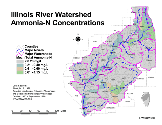
- 34 Ammonia-N Concentrations in the Illinois River Watershed
- Thematic map showing the mean total Ammonia-N for each of the major sub-watersheds.
- Download Options: LoRes preview | HiRes (624 K) | Metadata
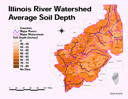
- 35 Average soil depth in the Illinois River Watershed
- Thematic map showing the average soil depth (inches) across the basin.
- Download Options: LoRes preview | HiRes (3.36 MB) | Metadata
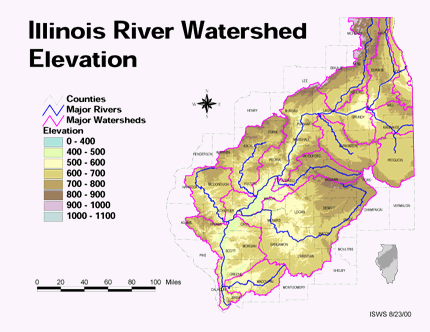
- 36 Elevation in the Illinois River Watershed
- Thematic map showing elevation changes in the basin.
- Download Options: LoRes preview | HiRes (1.76 MB) | Metadata
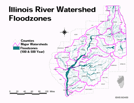
- 37 Floodzones in the Illinois River Watershed
- Thematic map showing the 100 and 500 year floodzones across the basin as of 1986.
- Download Options: LoRes preview | HiRes (3.77 MB) | Metadata
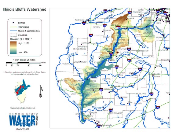
- 38 Illinois Bluffs Watershed
- Thematic map of the Illinois Bluffs watershed showing roads, county boundaries, and elevation changes.
- Download Options: LoRes preview | HiRes (2.26 MB) | Metadata
- 39 Illinois County Boundaries, Polygons and Lines
- GIS data - zipped shapefile

- 40 Illinois Floodplain Maps
- ISWS resource providing preliminary and final maps of Illinois floodplains.
- Home
- | Data
- | Maps/GIS
- | Models
- | Publications
- | Research
- | Agencies
- | Visualizations
All files and information © 2018 Illinois State Water Survey. Disclaimer.
Email the Web Administrator with questions or comments.