
- Home

- Counties - Champaign
- Search Results
Search Results
Search Results For:
County > Champaign
140 links were found.
Jump to: Data Online Maps/GIS Publications Research and Programs Agencies/Organizations
Displaying Page 2 (of 7)
Page: [<< Prev] 1 | 2 | 3 | 4 | 5 | 6 | 7 | [Next >>]
Data Online- 21 NTN data: Bondville, Champaign County, IL
- This National Trends Network (NTN) monitoring location provides long-term precipitation data for Bondville in Champaign County, IL.
- 22 Pan Evaporation Across Illinois
- Pan evaporation measurements taken at 9 sites across Illinois.
- 23 SANGAMON RIVER AT FISHER, IL - Water Data
- The USGS National Water Information System provides real-time and historical data on surface water flow, ground water levels, and water quality of streams in the US.
- 24 SANGAMON RIVER AT MAHOMET, IL - Water Data
- The USGS National Water Information System provides real-time and historical data on surface water flow, ground water levels, and water quality of streams in the US.
- 25 SANGAMON RIVER NEAR FISHER, IL - Water Data
- The USGS National Water Information System provides real-time and historical data on surface water flow, ground water levels, and water quality of streams in the US.
- 26 SANGAMON RIVER NEAR MAHOMET, IL - Water Data
- The USGS National Water Information System provides real-time and historical data on surface water flow, ground water levels, and water quality of streams in the US.
- 27 Upper Kaskaskia Watershed Profile
- Environmental Protection Agency website containing numerous links to environmental data about the Upper Kaskaskia watershed.
- 28 Upper Kaskaskia Watershed Resource Links
- USGS maintained site with links to data, projects, and publications on HUC watersheds.
- 29 Upper Kaskaskia Watershed Water Data
- The USGS National Water Information System provides real-time and historical data on surface water flow, ground water levels, and water quality of streams in the US.
- 30 Upper Sangamon Watershed Profile
- Environmental Protection Agency website containing numerous links to environmental data about the Upper Sangamon watershed.
- 31 Upper Sangamon Watershed Resource Links
- USGS maintained site with links to data, projects, and publications on HUC watersheds
- 32 Upper Sangamon Watershed Water Data
- The USGS National Water Information System provides real-time and historical data on surface water flow, ground water levels, and water quality of streams in the US.
- 33 Vermilion (Wabash Basin) Watershed Profile
- Environmental Protection Agency website containing numerous links to environmental data about the Vermilion watershed.
- 34 Vermilion (Wabash Basin) Watershed Resource Links
- USGS maintained site with links to data, projects, and publications on HUC watersheds.
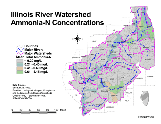
- 35 Ammonia-N Concentrations in the Illinois River Watershed
- Thematic map showing the mean total Ammonia-N for each of the major sub-watersheds.
- Download Options: LoRes preview | HiRes (624 K) | Metadata
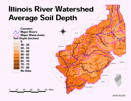
- 36 Average soil depth in the Illinois River Watershed
- Thematic map showing the average soil depth (inches) across the basin.
- Download Options: LoRes preview | HiRes (3.36 MB) | Metadata
- 37 Champaign County Coal Maps
- ISGS Coal Map Series. Includes mines, resources, and logs.
- 38 Champaign County Orthophotography Data 1998-1999
- Illinois National Aerial Photography Program Digital Orthophotography quarter Quadrangle data for Champaign County in the Universal Transverse Mercator (UTM) coordinate system with a NAD83 datum.

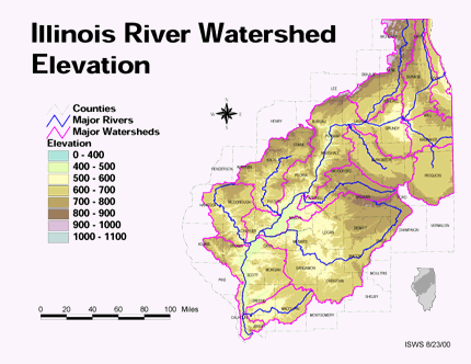
- 39 Elevation in the Illinois River Watershed
- Thematic map showing elevation changes in the basin.
- Download Options: LoRes preview | HiRes (1.76 MB) | Metadata
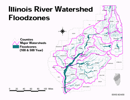
- 40 Floodzones in the Illinois River Watershed
- Thematic map showing the 100 and 500 year floodzones across the basin as of 1986.
- Download Options: LoRes preview | HiRes (3.77 MB) | Metadata
- Home
- | Data
- | Maps/GIS
- | Models
- | Publications
- | Research
- | Agencies
- | Visualizations
All files and information © 2018 Illinois State Water Survey. Disclaimer.
Email the Web Administrator with questions or comments.