
- Home

- Counties - Piatt
- Search Results
Search Results
Search Results For:
County > Piatt
104 links were found.
Jump to: Data Online Maps/GIS Publications Research and Programs Agencies/Organizations
Displaying Page 3 (of 6)
Page: [<< Prev] 1 | 2 | 3 | 4 | 5 | 6 | [Next >>]
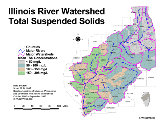
Maps/GIS- 41 Total suspended solids in the Illinois River Watershed
- Thematic map showing the mean TSS concentrations for each of the major sub-watersheds.
- Download Options: LoRes preview | HiRes (626 K) | Metadata
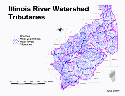
- 42 Tributaries in the Illinois River Watershed
- Thematic map showing the tributaries throughout the basin.
- Download Options: LoRes preview | HiRes (1.43 MB) | Metadata
 = Abstract available
  = Full Text available
  = Fact Sheet available
  = PDF format
  = HTML format
  = PowerPoint format
- 43 100 - year rainstorms in the Midwest: design characteristics


- Huff, Floyd A., 1993 ISWS C-176
- 44 7-day 10-year low flows of streams in the Kankakee, Sangamon, Embarras, Little Wabash, and southern regions
- Singh, Krishan P., Ganapathi S. Ramamurthy, and Il Won Seo, 1988 ISWS CR-441
- 45 7-day 10-year low flows of streams in the Rock, Spoon, La Moine, and Kaskaskia regions
- Singh, Krishan P., Ganapathi S. Ramamurthy, and Il Won Seo, 1988 ISWS CR-440
- 46 A summary of information related to the comprehensive management of groundwater and surface water resources in the Sangamon River Basin, Illinois
- O'Hearn, Michael, and Tamara L. Williams, 1982 ISWS CR-299
- 47 Adequacy of Illinois surface water supply systems to meet future demands
- McConkey Broeren, Sally, and Krishan P. Singh, 1989 ISWS CR-477
- 48 Analysis of 1952 radar and raingage data
- Neill, James C., 1953 ISWS RI-21
- 49 Analysis of Nutrients, Selected Inorganic Constituents, and Trace Elements in Water From Illinois Community-supply Wells, 1984-91
- Online USGS report
- Warner, K.L., and A.R. Schmidt, 1999 U.S. Geological Survey Water-Resources Investigations Report 99-4152
- 50 Arsenic in groundwater in central Illinois.
- Kelly, Walt R., 2005 ISWS IEM 2005-02
- 51 Assessment of eighteen public ground-water supplies in Illinois
- Wehrmann, H. Allen, Adrian P. Visocky, Charles B. Burris, Robert W. Ringler, and Ross D. Brower, 1980 ISWS CR-237
- 52 Benchmark sediment monitoring program for Illinois streams : data report for water years 1994 and 1995.
- Allgire, Richard L., 2001 ISWS DCS 2001-01
- 53 Benchmark sediment monitoring program for Illinois streams : data report for Water Years 1996 and 1997.
- Allgire, Richard L., 2001 ISWS DCS 2001-02
- 54 Benchmark sediment monitoring program for Illinois streams : data report for Water Years 1998 and 1999
- Allgire, Richard L., 2002 ISWS DCS 2002-01
- 55 Benchmark sediment monitoring program for Illinois streams: data report for the water years 1992 and 1993
- Allgire, Richard L., 1997 ISWS C-183
- 56 Benchmark sediment monitoring program for Illinois streams: program summary and site descriptions.
- Allgire, Richard L., and Misganaw Demissie, 1995 ISWS C-181
- 57 Conventional urbanization and its effect on storm runoff
- Terstriep, Michael L., Michael L. Voorhees, and G. Michael Bender, 1976 ISWS CR-177
- 58 Environmentally acceptable morphologic channel design of streams with small to medium-sized drainage areas
- McConkey Broeren, Sally, and Krishan P. Singh, 1990 ISWS CR-495
- 59 Fate of Arsenic in the Mahomet Aquifer: The Influence of Added Sulfate and Nitrate
- Sanford, Robert, Theodore Flynn, Thomas Holm, Walton Kelly, 2009 ISWS CR 2009-01
- 60 Groundwater availability in Piatt County
- Sanderson, Ellis W., 1971 ISWS C-107
- Home
- | Data
- | Maps/GIS
- | Models
- | Publications
- | Research
- | Agencies
- | Visualizations
All files and information © 2018 Illinois State Water Survey. Disclaimer.
Email the Web Administrator with questions or comments.