
- Home
 Watersheds
 - Watersheds - Iroquois
Watersheds - Iroquois
Watershed Profile
Name
Iroquois
USGS Cataloging Unit
07120002
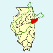
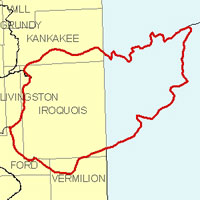
Description
The Iroquois watershed in northeastern Illinois and northwestern Indiana is part of the Kankakee River basin. With drainage from four Illinois counties, the Illinois portion of the watershed has a total area of approximately 1,290 square miles. Agriculture is the primary use of land within the watershed.
Web Resources
- Iroquois Watershed web links
- View all of the Iroquois Watershed links in the ILRDSS database.
- Iroquois River at Rensselaer Stage Data and Forecasts
- Provides real time data on river conditions as well as warning and forecasts.
Jump to another watershed
- Home
- | Data
- | Maps/GIS
- | Models
- | Publications
- | Research
- | Agencies
- | Visualizations
All files and information © 2018 Illinois State Water Survey. Disclaimer.
Email the Web Administrator with questions or comments.