
- Home
 Watersheds
 - Watersheds - Mississippi River Valley
Watersheds - Mississippi River Valley
Watershed Profile
Name
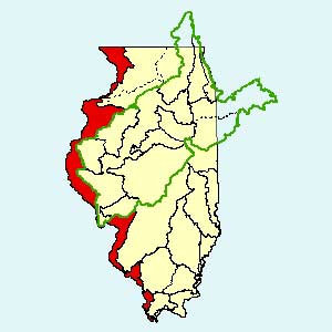
Mississippi River Valley
USGS Cataloging Unit
07060005, 07080101, 07080104, 07110001, 07110004, 07110009, 07140101, 07140105
Description
The Mississippi River Valley in western Illinois is the land area drained by the main stem of the Mississippi River, excluding its major Illinois tributaries: the Rock, Illinois, Kaskaskia, Big Muddy, and Cache. Agriculture is the primary use of land within the watershed, although many grasslands and forests are present as well.
Web Resources
- Mississippi River Valley Watershed web links
- View all of the Mississippi River Valley Watershed links in the ILRDSS database.
- 1993 Mississippi River Flood Precipitation Data
- This ISWS resource provides non-federal and non-archived federal data on the hydrometeorology and hydrology of the 1993 Mississippi River Flood.
Jump to another watershed
- Home
- | Data
- | Maps/GIS
- | Models
- | Publications
- | Research
- | Agencies
- | Visualizations
All files and information © 2018 Illinois State Water Survey. Disclaimer.
Email the Web Administrator with questions or comments.