
- Home
 Watersheds
 - Watersheds - Rock
Watersheds - Rock
Watershed Profile
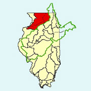
Name
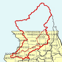
Rock
USGS Cataloging Unit
07090001, 07090003, 07090004, 07090005, 07090006 (Kishwaukee), 07090007 (Green)
Description
The Rock watershed in northern Illinois and southern Wisconsin is part of the Mississippi River basin. Together with its major tributaries, the Green and Kishwaukee rivers, the watershed drains parts or all of 15 Illinois counties and has a total area in Illinois of approximately 5,330 square miles. Agriculture is the primary use of land within the watershed.
Web Resources
- Rock Watershed web links
- View all of the Rock Watershed links in the ILRDSS database.
- The Illinois Streamflow Assessment Model (ILSAM)
- Stream flow estimates for streams located within the Rock watershed.
Jump to another watershed
- Home
- | Data
- | Maps/GIS
- | Models
- | Publications
- | Research
- | Agencies
- | Visualizations
All files and information © 2018 Illinois State Water Survey. Disclaimer.
Email the Web Administrator with questions or comments.