
- Home
 Watersheds
 - Watersheds - Kishwaukee
Watersheds - Kishwaukee
Watershed Profile
Name
Kishwaukee
USGS Cataloging Unit
07090006
Description
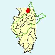
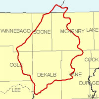
The Kishwaukee watershed in northern Illinois and southern Wisconsin is part of the Rock River basin. With drainage from seven Illinois counties, the Illinois portion of the watershed has a total area of approximately 1,220 square miles. Agriculture is the primary use of land within the watershed, but there are also many grasslands scattered throughout the area.
Web Resources
- Kishwaukee Watershed web links
- View all of the Kishwaukee Watershed links in the ILRDSS database.
- Kishwaukee Watershed Water Data
- The USGS National Water Information System provides real-time and historical data on surface water flow, ground water levels, and water quality of streams in the US.
Jump to another watershed
- Home
- | Data
- | Maps/GIS
- | Models
- | Publications
- | Research
- | Agencies
- | Visualizations
All files and information © 2018 Illinois State Water Survey. Disclaimer.
Email the Web Administrator with questions or comments.