
- Home
 About the ILRDSS
- Framework
About the ILRDSS - Framework
ILRDSS System Framework
This network and communication framework includes information resources, modular databases, and simulation models to evaluate the impact of water resources development, land-use changes, economic development, and climate variability on sedimentation, water quality, ecology, hydrology, and hydraulics in terms of long-term restoration and sustainability of the Illinois River.
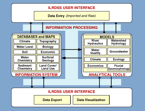
The figure below displays in red the simplified relationships among the four main components of the ILRDSS: (1) the information system containing databases, maps, and other data products; (2) simulation and assessment models in the analytical tools component; (3) the user interface; and (4) the ILRDSS information processing system that allows information transfer among all the components. The diagram also details potential data and modeling subcomponents for inclusion in the information system and analytical tool modules. Early ILRDSS versions will provide basic information exchange between each user and individual data and tool components via direct database access and web-based interfaces. Later work will add web-based interactive modeling and simulation features with direct links to ILRDSS databases and models.
Initial ILRDSS users are expected to be scientists and professionals within state and federal agencies. As the ILRDSS expands and more components are added to aid in decision processes, system users will include a broader range of decision-makers.
- Home
- | Data
- | Maps/GIS
- | Models
- | Publications
- | Research
- | Agencies
- | Visualizations
All files and information © 2018 Illinois State Water Survey. Disclaimer.
Email the Web Administrator with questions or comments.