
- Home

- Counties - Jersey
- Search Results
Search Results
Search Results For:
County > Jersey
99 links were found.
Jump to: Data Online Maps/GIS Publications Research and Programs Agencies/Organizations
Displaying Page 2 (of 5)
Page: [<< Prev] 1 | 2 | 3 | 4 | 5 | [Next >>]
Data Online- 21 Peruque-Piasa Watershed Water Data
- The USGS National Water Information System provides real-time and historical data on surface water flow, ground water levels, and water quality of streams in the US.
- 22 1993 Mississippi River Flood Hazard Mitigation Grant Program
- 1993 Mississippi River flood maps that show properties damaged in the event.
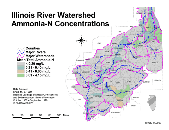
- 23 Ammonia-N Concentrations in the Illinois River Watershed
- Thematic map showing the mean total Ammonia-N for each of the major sub-watersheds.
- Download Options: LoRes preview | HiRes (624 K) | Metadata
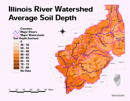
- 24 Average soil depth in the Illinois River Watershed
- Thematic map showing the average soil depth (inches) across the basin.
- Download Options: LoRes preview | HiRes (3.36 MB) | Metadata
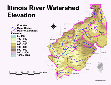
- 25 Elevation in the Illinois River Watershed
- Thematic map showing elevation changes in the basin.
- Download Options: LoRes preview | HiRes (1.76 MB) | Metadata
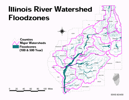
- 26 Floodzones in the Illinois River Watershed
- Thematic map showing the 100 and 500 year floodzones across the basin as of 1986.
- Download Options: LoRes preview | HiRes (3.77 MB) | Metadata
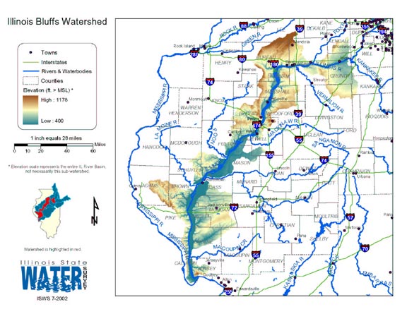
- 27 Illinois Bluffs Watershed
- Thematic map of the Illinois Bluffs watershed showing roads, county boundaries, and elevation changes.
- Download Options: LoRes preview | HiRes (2.26 MB) | Metadata
- 28 Illinois County Boundaries, Polygons and Lines
- GIS data - zipped shapefile

- 29 Illinois Floodplain Maps
- ISWS resource providing preliminary and final maps of Illinois floodplains.
- 30 Illinois River Basin GIS Data Viewer
- Interactive map provided by the ISWS. Viewable layers include watersheds, rivers, water quality, geology, and groundwater.
- 31 Illinois River Basin Weather Stations
- The weather stations in this data set were gathered from the WDM database within the Basins watershed modeling program. Coordinates for the stations were exported from Basins, then formatted and imported into ArcGIS. This data set was created to support research at the Illinois State Water Survey. (shapefile, .zip archive)
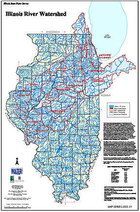
- 32 Illinois River Watershed - Poster
- Poster-sized (26x38) map of the entire Illinois River Watershed. Part of the Illinois State Water Survey published Map Series (2003-1)
- Download Options: LoRes preview | HiRes (3.5 MB) | Metadata
- 33 Jersey County Coal Maps
- ISGS Coal Map Series. Includes mines, resources, and logs.
- 34 Jersey County Orthophotography Data 1998-1999
- Illinois National Aerial Photography Program Digital Orthophotography quarter Quadrangle data for Jersey County in the Universal Transverse Mercator (UTM) coordinate system with a NAD83 datum.
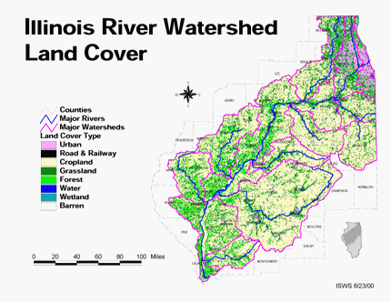
- 35 Land cover in the Illinois River Watershed
- Thematic map showing land cover from raster imagery.
- Download Options: LoRes preview | HiRes (2.68 MB) | Metadata
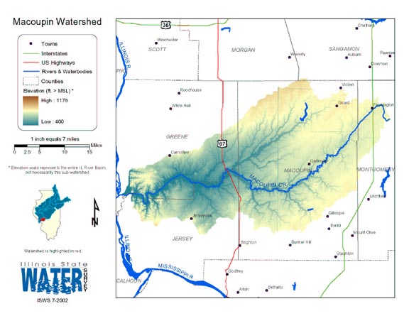
- 36 Macoupin Watershed
- Thematic map of the Macoupin watershed showing roads, county boundaries, and elevation changes.
- Download Options: LoRes preview | HiRes (2.13 MB) | Metadata
- 37 Major Watersheds of Illinois
- Poster-sized (26x38) map of the major watersheds in Illinois. Part of the Illinois State Water Survey published Map Series (2000-01)
- Download Options: LoRes preview | HiRes (730 K) | Metadata
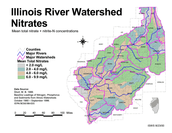
- 38 Nitrates in the Illinois River Watershed (mean total nitrate + nitrite-N concentrations)
- Thematic map showing the mean total nitrate + nitrite-N concentrations for each of the major sub-watersheds.
- Download Options: LoRes preview | HiRes (624 K) | Metadata
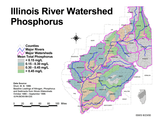
- 39 Phosphorus in the Illinois River Watershed
- Thematic map showing the mean total phosphorus concentrations for each of the major sub-watersheds.
- Download Options: LoRes preview | HiRes (624 K) | Metadata
- 40 Resource Management Mapping Service
- Interactive map that allows users to locate, create, and print maps of large and small areas within Illinois. Natural resource, administrative, and economic layers available.
- Home
- | Data
- | Maps/GIS
- | Models
- | Publications
- | Research
- | Agencies
- | Visualizations
All files and information © 2018 Illinois State Water Survey. Disclaimer.
Email the Web Administrator with questions or comments.