
- Home

- Watersheds - Fox
- Search Results
Search Results
Search Results For:
Watershed > Fox
45 links were found.
Displaying Page 2 (of 3)
Page: [<< Prev] 1 | 2 | 3 | [Next >>]
Maps/GIS- 21 Fox Watershed - NPDES Permits
- NPDES discharges in the Fox River watershed. Location and attributes were downloaded from the USEPA EnviroFacts Data Warehouse (http://www.epa.gov/enviro/ accessed May - November 2003) and checked against the description. The ISWS 1996 dataset on NPDES was used for additional verification. Dataset has been submitted to the Fox River Study Group, Inc. (FRSG) for comments and updates. (shapefile, .zip archive)

- 22 Fox Watershed - Population Density
- This geospatial dataset is a hydrologic unit boundary layer that is at the Subwatershed (12-digit) level clipped to the Fox watershed boundary. The population density field was added and was calculated as pop field/sq mi. (shapefile, .zip archive)
- 23 Fox Watershed - Towns (selected)
- This is a set of county by county point coverages of towns in Illinois. Point locations approximate towns center. This feature class represents selected communities in Fox River basin in Illinois, Some town locations were arbitrarily deleted for cartographic reasons. (shapefile, .zip archive)
- 24 Fox Watershed - Water Quality Sample Sites
- This data set describes the locations of water quality samples taken in the Fox Watershed (Illinois and Wisconsin portions). Sample data is stored in a SQL Server database, and the location table is regularly exported to create stand-alone shapefiles of sample locations. This data set was created on 5/27/03. (shapefile, .zip archive)
- 25 Fox Watershed GIS Data Viewer
- Interactive map provided by the ISWS. Viewable layers include gages/sample sites, water resources, land resources, and administrative.
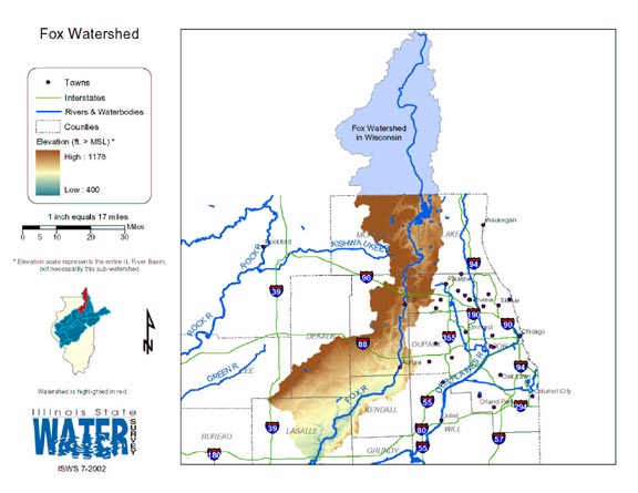
- 26 Fox Watershed Map
- Thematic map of the Fox watershed showing roads, county boundaries, and elevation changes.
- Download Options: LoRes preview | HiRes (1.16 MB) | Metadata
- 27 Illinois Floodplain Maps
- ISWS resource providing preliminary and final maps of Illinois floodplains.
- 28 Illinois River Basin GIS Data Viewer
- Interactive map provided by the ISWS. Viewable layers include watersheds, rivers, water quality, geology, and groundwater.
- 29 Illinois River Basin Weather Stations
- The weather stations in this data set were gathered from the WDM database within the Basins watershed modeling program. Coordinates for the stations were exported from Basins, then formatted and imported into ArcGIS. This data set was created to support research at the Illinois State Water Survey. (shapefile, .zip archive)
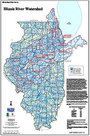
- 30 Illinois River Watershed - Poster
- Poster-sized (26x38) map of the entire Illinois River Watershed. Part of the Illinois State Water Survey published Map Series (2003-1)
- Download Options: LoRes preview | HiRes (3.5 MB) | Metadata
- 31 Kane County Orthophotography Data 1998-1999
- Illinois National Aerial Photography Program Digital Orthophotography quarter Quadrangle data for Kane County in the Universal Transverse Mercator (UTM) coordinate system with a NAD83 datum.
- 32 Kendall County Orthophotography Data 1998-1999
- Illinois National Aerial Photography Program Digital Orthophotography quarter Quadrangle data for Kendall County in the Universal Transverse Mercator (UTM) coordinate system with a NAD83 datum.
- 33 Lake County Orthophotography Data 1998-1999
- Illinois National Aerial Photography Program Digital Orthophotography quarter Quadrangle data for Lake County in the Universal Transverse Mercator (UTM) coordinate system with a NAD83 datum.
- 34 Land cover in the Illinois River Watershed
- Thematic map showing land cover from raster imagery.
- Download Options: LoRes preview | HiRes (2.68 MB) | Metadata
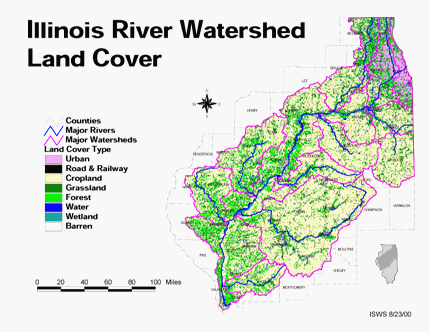
- 35 LaSalle County Coal Maps
- ISGS Coal Map Series. Includes mines, resources, and logs.
- 36 Lasalle County Orthophotography Data 1998-1999
- Illinois National Aerial Photography Program Digital Orthophotography quarter Quadrangle data for Lasalle County in the Universal Transverse Mercator (UTM) coordinate system with a NAD83 datum.
- 37 Lee County Orthophotography Data 1998-1999
- Illinois National Aerial Photography Program Digital Orthophotography quarter Quadrangle data for Lee County in the Universal Transverse Mercator (UTM) coordinate system with a NAD83 datum.
- 38 Major Watersheds of Illinois
- Poster-sized (26x38) map of the major watersheds in Illinois. Part of the Illinois State Water Survey published Map Series (2000-01)
- Download Options: LoRes preview | HiRes (730 K) | Metadata
- 39 McHenry County Orthophotography Data 1998-1999
- Illinois National Aerial Photography Program Digital Orthophotography quarter Quadrangle data for McHenry County in the Universal Transverse Mercator (UTM) coordinate system with a NAD83 datum.
- 40 Nitrates in the Illinois River Watershed (mean total nitrate + nitrite-N concentrations)
- Thematic map showing the mean total nitrate + nitrite-N concentrations for each of the major sub-watersheds.
- Download Options: LoRes preview | HiRes (624 K) | Metadata
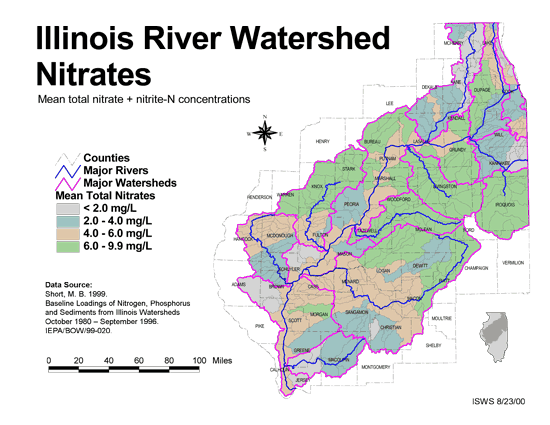
- Home
- | Data
- | Maps/GIS
- | Models
- | Publications
- | Research
- | Agencies
- | Visualizations
All files and information © 2018 Illinois State Water Survey. Disclaimer.
Email the Web Administrator with questions or comments.