
- Home

- Watersheds - Vermilion-Illinois Basin
- Search Results
Search Results
Search Results For:
Watershed > Vermilion-Illinois Basin
132 links were found.
Jump to: Data Online Maps/GIS Models Publications Research and Programs Agencies/Organizations
Displaying Page 4 (of 7)
Page: [<< Prev] 1 | 2 | 3 | 4 | 5 | 6 | 7 | [Next >>]
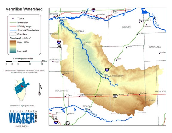
Maps/GIS- 61 Vermilion (Illinois Basin) Watershed Map
- Thematic map of the Vermilion watershed showing roads, county boundaries, and elevation changes.
- Download Options: LoRes preview | HiRes (2.01 MB) | Metadata
- 62 Woodford County Coal Maps
- ISGS Coal Map Series. Includes mines, resources, and logs.
- 63 Woodford County Orthophotography Data 1998-1999
- Illinois National Aerial Photography Program Digital Orthophotography quarter Quadrangle data for Woodford County in the Universal Transverse Mercator (UTM) coordinate system with a NAD83 datum.

- 64 Watershed Models
- Links to simple overviews of various landscape/watershed simulation models. Site maintained by the Environmental Protection Agency.
 = Abstract available
  = Full Text available
  = Fact Sheet available
  = PDF format
  = HTML format
  = PowerPoint format
- 65 7-day 10-year low flows of streams in the Kankakee, Sangamon, Embarras, Little Wabash, and southern regions


- Singh, Krishan P., Ganapathi S. Ramamurthy, and Il Won Seo, 1988 ISWS CR-441
- 66 Adequacy of Illinois surface water supply systems to meet future demands
- McConkey Broeren, Sally, and Krishan P. Singh, 1989 ISWS CR-477
- 67 Algae in selected Illinois streams, 1971-1976
- Lin, Shundar, Ralph L. Evans, and Davis B. Beuscher, 1978 ISWS RI-86
- 68 An investigation of historical temperature and precipitation data at climate benchmark stations in Illinois
- Changnon, Stanley A., Jr., Derek Winstanley, and Kenneth E. Kunkel, 1997 ISWS C-184
- 69 Analysis of Nutrients, Selected Inorganic Constituents, and Trace Elements in Water From Illinois Community-supply Wells, 1984-91
- Online USGS report
- Warner, K.L., and A.R. Schmidt, 1999 U.S. Geological Survey Water-Resources Investigations Report 99-4152
- 70 Benchmark sediment monitoring program for Illinois streams : data report for water years 1994 and 1995.
- Allgire, Richard L., 2001 ISWS DCS 2001-01
- 71 Benchmark sediment monitoring program for Illinois streams : data report for Water Years 1996 and 1997.
- Allgire, Richard L., 2001 ISWS DCS 2001-02
- 72 Benchmark sediment monitoring program for Illinois streams : data report for Water Years 1998 and 1999
- Allgire, Richard L., 2002 ISWS DCS 2002-01
- 73 Benchmark sediment monitoring program for Illinois streams: data report for the water years 1992 and 1993
- Allgire, Richard L., 1997 ISWS C-183
- 74 Benchmark sediment monitoring program for Illinois streams: program summary and site descriptions.
- Allgire, Richard L., and Misganaw Demissie, 1995 ISWS C-181
- 75 Concentration and genera of algae in selected Illinois streams, 1971-1973
- Lin, Shun Dar, Ralph L. Evans, and Davis B. Beuscher, 1975 ISWS RI-80
- 76 Determination of stream width and elevation at selected gaging stations in Illinois for Soil Conservation Service wetland mapping
- Ramamurthy, Ganapathi S., Ming T. Lee, and Krishan P. Singh, 1989 ISWS CR-462
- 77 Evaluation of hydraulic geometry parameters for various low-flow releases downstream of dams on Illinois streams
- Singh, Krishan P., 1981 ISWS CR-251
- 78 Flood Tracking Chart for the Illinois River Basin

- Online report describing how to record and compare predicted or current flood-crest state to past flood-crest information to make informed decisions concerning flood threat. US Geological Survey Open-File Report 98-390
- Avery, C., R.R. Holmes, Jr., and J.B. Sharpe, 1998 U.S. Geologcial Survey Open-File Report 98-390
- 79 Future water demands of public surface water supply systems in Illinois
- Singh, Krishan P., Sally McConkey Broeren, Robin B. King, and Michael L. Pubentz, 1988 ISWS CR-442
- 80 Governors Conference on the Management of the Illinois River - 1987 Conference Proceedings
- Proceedings from the biennial conference on the management of the Illinois River and its watershed.
- Multiple authors, 1987
- Home
- | Data
- | Maps/GIS
- | Models
- | Publications
- | Research
- | Agencies
- | Visualizations
All files and information © 2018 Illinois State Water Survey. Disclaimer.
Email the Web Administrator with questions or comments.